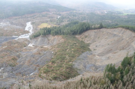
— This is not meant to alarm anyone, but please keep this photo in mind. It was taken by the Washington National Guard last year and shows the mudslide that hit Oso, Washington, in March 2014. The earth simply collapsed over a width of one mile, and forty three people died that Saturday morning. For comparison, the slide was more than double the width of the Mendenhall Glacier.

Afterwards, a Washington state commission made several recommendations to increase public awareness and warnings of landslide risk, to discourage building in potential landslide zones, and to do more surveys to identify where those risks are located. Here’s a summary.
KUOW reported on the recommendations:
A KUOW/Earthfix investigation in September found that most Washington counties routinely allow homes to be built 50 feet or less from known landslide zones, although landslides often travel hundreds of feet. The extremely large Oso slide traveled more than 3,000 feet from the base of the well-known landslide slope along the North Fork Stillaguamish River.
With that in mind, consider the weather reports from just one day in Southeast Alaska. And especially notice the dates of the records that are falling.
…Record daily maximum temperatures on Thursday…
| Location |
new record |
old record |
year set |
| Skagway Airport |
49 |
tied 49 |
2014 |
| Haines Airport |
48 |
46 |
2014 |
| Juneau Airport |
48 |
47 |
2014 |
| wfo Juneau |
50 |
48 |
2014 |
…Record daily high minimum temperatures on Thursday…
| Location |
new record |
old record |
year set |
| wso Yakutat |
42 |
41 |
2014 |
| Haines Airport |
44 |
37 |
1985 |
| Juneau Airport |
44 |
38 |
2001 |
| wfo Juneau |
43 |
37 |
2001 |
| Petersburg Airport |
45 |
tied 45 |
2014 |
| Klawock Airport |
46 |
tied 46 |
2014 |
| Ketchikan Airport |
47 |
45 |
2014 |
| wso Annette |
47 |
44 |
1987 |
Rainfall records are breaking all over Southeast this month, too, so I won’t try to keep up with the numbers. Records in that category are just like the temperatures. This year, communities are breaking records from last year. And we don’t see an immediate break on the way.
Special Statement
Statement as of 3:33 PM AKST on January 23, 2015
The active weather pattern will continue through Saturday. The next storm system is projected to impact northern and central Panhandle with heavy rain and windy conditions. 2 to 3 inches are expected through Saturday night…with locally higher amounts. Wind gusts of 40 mph or higher are expected.
Impacts – expect small streams to rise and approach bank full Friday night. Windy conditions may interrupt power and uproot trees. Mudslides and landslides are likely.
Please stay tuned to your favorite weather information sources for updates on the progress of the heavy rain and wind.
One conclusion is that we are beginning to see a trend in Alaska. Temperatures and rainfall are increasing every year. From national statistics that trend has grown for more than a decade and by every outlook I have seen, it will continue. I have my ideas on what’s causing it, you have yours. I don’t care about passing the buck, I want solutions.
We, as a society, need to look at how we are dealing with it. How about local governments – or volunteers — doing some surveys to give a hint at where there are risks. I know of a small landslide some years back uphill from my house, another two closer to the Gastineau Channel. I bet there are others just in Juneau. I bought insurance that should protect the investment in my house. I sleep with my boots by the bed.
If I were a leader, I would encourage some organization to come up with preparing for a disaster. There are lessons from Oso, Washington, that we need to take the time to learn.
#